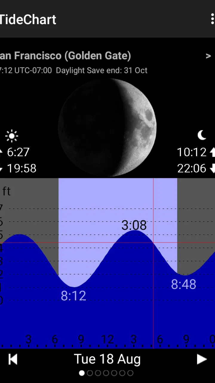
Tide Table Chart
- 3.0
- Rating
- 10.00K
- Installs
- $4.99
- Price

 Analysis by App-foxy
I like tide apps that get out of the way. When I am standing near a harbor, planning a beach walk, or checking whether a low-water window will suit a shoreline visit, I do not want a crowded travel dashboard. I want a readable answer about the next high and low tides. Tide Table Chart takes that focused approach. It is a paid Travel & Local app from AppMosaic, built around tide forecasts rather than maps, trip booking, weather alerts, or social features.
That narrow purpose is both its appeal and its main limitation. In my experience, the app makes sense for someone who already knows the coastal location they want to check and prefers a direct chart-style reference. It is less convincing for travelers who expect a complete coastal-planning tool or a modern weather companion. The average rating is 3.0 from around 231 ratings, while its install count is over 10K, so it has found a modest audience without looking like a universally loved utility.
Getting past the first points of friction
The first thing I would clarify before installing it is what kind of problem this app solves. It is not a general navigation app, and it should not be treated as a replacement for a marine weather service. Its job is to provide access to high- and low-tide forecasts. That sounds simple, but it changes how you should approach the interface: start with the location and the tide information, not with expectations of a full itinerary or live coastal warning system.
You May Also Like

 Pandora - Music & Podcasts
Pandora’s Music Is Easy to Start, but Harder to Recover
Pandora’s strength is its low-effort path from a seed to a station. Its weak spot is how much confidence it asks you to place in connection, setup, and quiet recovery.

 8 Ball Pool
 Is Built on Rivalries, Rematches, and Routine
A close look at the rivalries, rematches, shared routines, and unanswered safety questions that turn a quick pool match into a persistent mobile community.

 Samsung Music
’s Quiet Strength Is Playing What You Already Own
Its reach comes less from spectacle than from dependable access to a personal library. That simplicity is both the app’s strongest retention engine and its ceiling.

 AccuWeather: Weather Radar
AccuWeather Review: A Quick, Clear Forecast for Everyday Decisions
For everyday plans, the best forecast is the one you can understand quickly. AccuWeather makes rain timing, radar, and local conditions easy to act on, with a few trade-offs.

 Hill Climb Racing
Why Hill Climb Racing Still Turns Crashes Into One More Run
A tiny car, a bumpy hill and one more upgrade: Hill Climb Racing keeps resurfacing because its simple chaos makes every near-miss feel personal.

 AliExpress - Shopping App
AliExpress Makes Global Shopping Feel Personal, but Shoppers Bear the Risk
AliExpress turns a global marketplace into a pocket-sized discovery engine. Its reach is useful, its shopping loop compelling, and its trade-offs easy to miss.
More From Our News Desk
View All News


Users can get stuck when they expect the app to behave like a current-location tool. Tide information is tied to a particular coastal station or place, so selecting the right location matters more than simply opening the app. If the displayed place is not the one closest to your intended shoreline, the times may be perfectly clear while still being unhelpful for your plan. I would always check the location label before relying on a chart, especially when visiting an unfamiliar coast with several nearby bays or ports.
Another common source of confusion is the difference between a forecast chart and a live observation. A tide chart tells you when water is expected to rise or fall; it does not automatically explain surf conditions, wind, rainfall, visibility, currents, or access restrictions. If I were planning a paddle, fishing trip, or long coastal walk, I would use this app for the tide window and consult a separate source for the conditions that could make the same tide unsafe or impractical.
The app costs $4.99, which makes the decision slightly different from trying a free utility and deleting it later. I would consider that price reasonable only if I expected to check tide times regularly or needed a dedicated reference without advertising-led clutter. Occasional vacation users may find a free web chart or a local authority page more suitable, particularly if they only need one location for one weekend.
What to check before trusting the first chart
My first setup check would be the date. Tide information is useful only when the selected day matches the actual outing, and a chart that looks correct can still be irrelevant if the calendar is left on another day. I would also look for the location name and confirm that it corresponds to the coast, harbor, or beach I intend to visit rather than assuming the nearest-looking result is automatically the best one.
A second check is the order of the tide events. High and low points are easy to skim incorrectly when I am in a hurry, especially if I am comparing an early-morning launch with a later return. I prefer to read the chart from the first event of the day onward, then write down the practical window I need. For example, instead of remembering only “low tide,” I would note whether I need the period before it, shortly after it, or the interval leading toward the next high tide.
The third check is consistency. If the chart appears empty, incomplete, or unexpectedly different from what I remember, I would first revisit the selected location and date rather than immediately assuming the app is broken. Tide schedules naturally change from day to day, and nearby stations can have noticeably different timings. A quick location-and-date review prevents a surprisingly large number of false alarms.
Because the app is an older release, version 1.8.3, I would also keep my expectations realistic about presentation. The release date is Jul 25, 2015, so this is not something I would choose for a polished, constantly evolving interface. Older utilities can still be useful when their core task is stable, but they may feel less intuitive on newer phones, especially if text, controls, or charts look dated compared with contemporary travel apps.
A practical routine for a beach day
Here is how I would use it for an ordinary coastal outing. The night before, I would select the intended place and date, identify the high and low points, and compare those times with the plan for parking, walking, launching, or returning. In the morning, I would check the same location again rather than relying on a screenshot from a different day. That second glance is useful because it catches accidental date changes and makes sure I am not planning around a neighboring station.
The non-obvious advantage of a focused tide chart is that it encourages better planning decisions. If I am taking a child to look at tide pools, the most useful moment may not be the exact low point; I may want enough time to arrive, walk down safely, and leave before the water returns too far. If I am photographing exposed rocks, the chart helps me choose a window, but it does not tell me whether the rocks will be slippery or whether the route will be accessible. The chart is a planning anchor, not the whole plan.
For fishing, I would use the app as a timing reference rather than a promise of good results. A tide change can influence where and when people fish, but species, local rules, weather, water temperature, and access all matter. That distinction is important because a simple chart can feel authoritative even when it covers only one part of the decision.
Recovering when the workflow goes wrong
When a result does not look right, I would recover in a fixed order. First, return to the selected location. Second, verify the date. Third, read the high and low entries in sequence. Only after those checks would I consider restarting the app or checking the device. This order is practical because a wrong selection is more likely to produce a misleading result than a failure of the entire tide calculation.
If the display seems stale, I would avoid making a last-minute safety decision from it alone. I would reopen the relevant chart, compare it with an official local source, and postpone the activity if the information still conflicts. That is not a criticism unique to this app; tide forecasts are planning information, and coastal conditions can change independently of the predicted water level.
It also helps to separate “the chart is unclear” from “the tide is inconvenient.” An awkward time is not an app error. If the low tide occurs while I am asleep or the high tide does not fit my travel schedule, the correct response is to adjust the outing or choose another day, not to keep refreshing the same screen. This sounds obvious, but it is an easy mistake when planning around a narrow window.
For a multi-stop trip, I would make a short written plan rather than switching locations repeatedly while walking. I would record the place, date, and the tide event that matters to me. That reduces the chance of returning to the app and accidentally checking a different station. It also makes the tool more useful offline in practice, because my decision is captured before I leave rather than depending on repeated browsing at the shoreline.
One trade-off is that the app’s narrow design may make it easier to focus, but it also means I have to supply the surrounding context myself. There is no reason to expect it to explain whether a path is open, whether a beach is lifeguarded, or whether a boat launch is usable. I would pair it with local access information and a weather source whenever the outing involves more than a casual walk.
When the problem is outside the app
Some tide-related surprises are caused by geography rather than software. A beach inside an inlet, a river mouth, or a sheltered bay may not behave exactly like an exposed coastal station. Even when two places look close on a map, their practical tide timing and water movement can differ. That is why I would choose the most relevant station available and treat a nearby station as an approximation, not a guarantee.
Weather can also make a tide prediction feel wrong. Strong wind or unusual atmospheric pressure can affect the actual water level, while waves and swell can make the shoreline look much higher or lower than the predicted tide suggests. If the chart and the sea appear to disagree, I would not use the chart to dismiss what I can see. I would check local marine conditions and choose the safer interpretation.
Currents are another separate issue. A high or low tide time does not describe every current hazard, and it does not tell me how quickly water will move through a narrow channel. For swimming, paddling, boating, or crossing tidal flats, I would look for dedicated local guidance. This is one of the clearest situations in which a specialist marine source is better than a simple tide chart.
Device behavior can create its own confusion. If the app looks cramped, text is difficult to read, or controls respond awkwardly, I would try rotating the phone, enlarging the display through system settings, or checking the same information on another screen before making a judgment about the forecast itself. These are general presentation checks, but they are especially relevant to an app released in an earlier smartphone era.
The Everyone age rating makes the app broadly approachable, but that does not make the activity automatically suitable for every user. A child can look at a tide chart with an adult, yet a child should not be allowed to treat the displayed times as permission to enter tidal areas. The important lesson is that accessibility of the app and safety of the shoreline are separate questions.
How it compares with the usual alternatives
Compared with a free website, this app’s strongest argument is convenience. A dedicated screen can be quicker than searching the web, dismissing pop-ups, and finding the correct station every time. That advantage matters if I check tides several times a week or want a simple reference while preparing gear. The weakness is that a web page from a harbor authority or coastal service may provide more local context, warnings, station notes, and related conditions.
Compared with a full weather app, Tide Table Chart is more focused but much less comprehensive. A weather app may combine wind, rain, temperature, wave information, and forecasts in one place, which is better for deciding whether an outing is comfortable or safe. This app is preferable when those extra panels would only slow me down and I already have another trusted source for weather.
Compared with a boating or fishing app, it is likely to feel lighter and easier to understand, but it should not be expected to replace navigation tools, nautical charts, current predictions, or local regulations. I would choose it for quick tide timing and choose a marine-focused product when the trip depends on navigation or changing hazards.
The paid model is therefore a personal value decision. Someone who wants one dependable, narrow-purpose reference may appreciate paying once for a dedicated tool. Someone who expects frequent updates, modern design, rich location discovery, or safety layers may feel that the price is harder to justify. The modest install base and middling average rating suggest that it is worth approaching as a specialized utility rather than assuming it will suit everyone.
Who should use it, and who should skip it?
I would recommend it to beach walkers, tide-pool visitors, casual anglers, photographers, and travelers who already know the coastal place they want to check. It is especially suitable for people who prefer a compact tide reference and are comfortable doing the surrounding research themselves. The best experience comes from treating the app as one step in a routine: select the right station, verify the date, read the tide sequence, and combine it with local conditions.
I would skip it if I wanted automatic trip planning, detailed maps, severe-weather notifications, current guidance, or a complete marine information package. I would also hesitate if I only needed a single tide lookup, because a free local source may offer better value for that limited use. The app is not a poor choice for being narrow; it is simply important to pay for the narrow function only when that function is genuinely useful to you.
For me, the deciding question would be frequency. If I lived near the coast and checked tide windows often, the direct format could earn its place on my phone. If I were visiting the coast once, I would first compare the cost and convenience with a local public tide source. That is the honest dividing line: regular use makes the focused design more defensible, while occasional use makes its limitations more noticeable.
My practical verdict
After using it as a tide reference, I see Tide Table Chart as a straightforward tool with a clearly defined job. It can help turn a vague plan such as “go when the tide is out” into a more useful schedule, provided I select the correct place and date. Its value comes from reducing that one lookup to a focused chart, not from offering a complete picture of the coast.
The friction is equally clear. The older release and $4.99 price make it less appealing to people who expect a polished modern travel app, while the limited scope means I still need weather, access, and safety information elsewhere. I would not use it as the only source for a boat trip, a tidal crossing, or any activity where currents and changing conditions matter.
My recommendation is conditional but positive: choose it if you want a dedicated high-and-low tide reference and will use it regularly. Before every outing, confirm the station and date, read the events in order, and treat the forecast as one planning ingredient rather than a safety clearance. Used that way, this Travel & Local app from AppMosaic remains a practical specialist utility, even if it is not the right choice for readers seeking an all-in-one coastal companion.
FAQs for Tide Table Chart
01What is Tide Table Chart used for?
Tide Table Chart is designed to help users check predicted tide information for coastal locations. It can be useful for planning fishing trips, boating, kayaking, beach visits, surfing, photography, and other activities affected by changing water levels. The app typically presents high and low tide times, tide heights, and date-based charts in a more convenient format than printed tide tables.
02How accurate are the tide predictions in Tide Table Chart?
Tide Table Chart predictions are generally based on astronomical calculations and location-specific tide data, so they can be helpful for planning. However, they should not be treated as exact real-time measurements. Weather conditions, wind, atmospheric pressure, storms, and local geography may change actual water levels. For safety-critical boating or coastal activities, users should compare the app with official marine forecasts and local authorities.
03Can I use Tide Table Chart without an internet connection?
Offline availability depends on the specific version of Tide Table Chart and whether location data has already been downloaded or stored on the device. Some information may remain accessible after loading a location, while maps, searches, updates, or additional stations may require an internet connection. Before traveling to an area with limited coverage, open the desired location in advance and confirm which features remain available offline.
04Does Tide Table Chart support locations around the world?
Tide Table Chart may include a broad selection of coastal stations, but coverage is not necessarily identical in every country or region. Availability depends on the data sources used by the app. Before downloading, users should search for their preferred harbor, beach, island, or coastal city and check whether a nearby tide station is listed. Predictions can be less representative when the selected station is far from the actual destination.
05Is Tide Table Chart free to download and use?
The app may be available as a free download, although some versions can include advertising, optional purchases, subscriptions, or restrictions on advanced features. These may involve removing ads, accessing additional locations, viewing longer prediction periods, or unlocking specialized charts. Users should review the current Google Play Store or Apple App Store listing because pricing, supported devices, and available features can change with future updates.
Pros
- Clear tide predictions help plan fishing
- boating
- and beach visits.
- Charts make high and low tide patterns easy to understand at a glance.
- Useful location-based information for many coastal areas worldwide.
- Lightweight design loads quickly and is simple to navigate.
- Practical offline access may help when traveling near remote shorelines.
Cons
- Coverage and prediction quality can vary between different coastal locations.
- Some features or locations may require an in-app purchase.
- Tide forecasts are estimates and should not replace official marine warnings.
- The interface may feel basic compared with more advanced marine apps.
- Users may need to search manually when automatic location detection fails.

Tide Table Chart
Gallery